L'aereoporto di St. Omer Arques - Myouth - Ricordi degli anni '70
Menu principale:
L'aereoporto di St. Omer Arques
Modellismo > Aerei > Messerschmitt Bf109-F2
Aeroporto di St. Omer-Arques
Emblema della Luftwaffe
Emblem of Luftwaffe
L'emblema dello Jagdgeschwader 53 (JG 53 - 53º stormo caccia)
Emblem of Jagdgeschwader 53 (JG 53)


 c'era un hangar a mezzaluna, la cui posizione contiene ancora i perni di ancoraggio e l'area interna. Il binario delle porte di chiusura è sempre visibile.")

Crediti per le immagini: Anciens Aérodromes
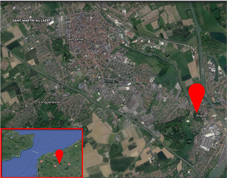
La zona dell'aeroporto, oggi
The airport area, today
Fonte/Source: Google Earth

Arques (FR) (St-Omer – Arques, St-Omer – Fort Rouge) (c. 50 43 55 N – 02 19 30 E)
Generale: campo d'aviazione nel nord-est della Francia, 5,25 km ESE di Saint-Omer, 2 km ESE del villaggio di Arques e situato tra una linea ferroviaria al largo del confine N e un canale al largo del confine S.
Storia: Arques fu sviluppato per la prima volta dai tedeschi il 40 agosto per essere usato come base di combattimento. Le unità si stabilirono lì fino al 42 settembre e da allora in poi furono usate principalmente come campo di puntaper missioni di allestimento.
Dimensioni: ca. 670 x 1370 metri (730 x 1500 iarde) e quasi rettangolare. L'area di atterraggio è stata mimetizzata per confondersi con la campagna circostante.
Superficie e piste: superficie erbosa che diventava veniva infradiciata dall'acqua in caso di pioggia. Aveva 1 pista di cemento lunga 670 metri (730 iarde) e allineata ENE / WSW. Attrezzato per atterraggi notturni.
Carburante e munizioni: c'era un solo ciclo di rifornimento nel deposito a Nord e un deosito di carburante a NE ai margini della foresta di Clairmarais. Altro deposito di carburante potrebbe essere stato fuori dall'angolo nord-ovest. Il principale deposito di munizioni si trovava probabilmente nella foresta di Clairmarais con un deposito più piccolo e pronto per l'utilizzo in capannoni nelle aree di rifornimento a Nord e a Sud.
Infrastruttura: aveva 1 piccolo hangar di riparazione all'angolo nord-ovest nell'area di dispersione e un altro 1,5 km a nord-est, ai margini della foresta di Clairmarais, che era collegato al campo d'aviazione da una pista di rullaggio. I piccoli capannoni vicino ai vertici a nord-ovest e nord-est erano probabilmente officine. Il quartier generale della stazione era all'angolo nord-ovest, con uffici e caserme negli angoli nord-est e nord-ovest. Si pensa che il controllo del volo della stazione si trovasse sul confine Sud. Piccoli edifici nell'area meridionale furono usati come deposito. Numerosi edifici della caserma nella foresta di Clairmarais potrebbero aver ospitato il personale della base, mentre il personale di volo e alcuni ufficiali erano alloggiati ad Arques. Le linee ferroviarie passavano vicino ai confini Ovest e Sud e all'angolo NE.
Dispersione: le 2 dispersioni - Nord e Sud - avevano un totale di 35 rifugi aerei di medie e 24 piccole dimensioni. La maggior parte dei rifugi sono stati scoperti e ed erano tutti mimetizzati per sembrare collinette e case. Le dispersioni erano collegate all'area di atterraggio da vie di rullaggio.
Difese: consisteva in 2 posizioni di Flak pesanti e 14 leggeri in Apr 43 ridotte poi a 2 Flak pesanti e 7 leggere
Fonte: Luftwaffe Airfields 1935-45 France (with Corsica and Channel Islands) By Henry L. de Zeng IV
Arques (FR) (St-Omer – Arques, St-Omer – Fort Rouge) (c. 50 43 55 N – 02 19 30 E)
General: airfield in NE France 5.25 km ESE of Saint-Omer, 2 km ESE of the village of Arques and lying between a railway line off the N boundary and a canal off the S boundary.
History: Arques was first developed by the Germans in Aug 40 for use as a fighter base. Units were based there until Sep 42 and thereafter it was used mainly as a forward field for staging missions.
Dimensions: approx. 670 x 1370 meters (730 x 1500 yards) and nearly rectangular in shape. The landing area was camouflaged to blend in with the surrounding countryside.
Surface and Runways: grass surface that became water-logged in wet weather. Had 1 concrete runway 670 meters (730 yards) in length and aligned ENE/WSW. Equipped for night landings.
Fuel and Ammunition: there was a single refueling loop in the North dispersal and a bulk fuel dump NE on the fringe of the Clairmarais Forest. Other fuel storage may have been off the NW corner. The main ammunition dump was probably in the Clairmarais Forest with smaller, ready to issue storage in sheds in the North and South dispersal areas.
Infrastructure: had 1 small repair hangar off the NW corner in the dispersal area and another 1.5 km to the NE on the fringe of the Clairmarais Forest that was connected to the airfield by a taxi track. Small huts near the NW and NE corners were most likely workshops. The station HQ was off the NW corner, with offices and barracks of both the NE and NW corners. Station flight control was believed to be on the S boundary. Small buildings in the South dispersal were used as billets and for storage. A number of barrack buildings in the Clairmarais Forest may have housed base personnel, while flying personnel and some officers were quartered in Arques. Railway lines passed close to the W and S boundaries and to the NE corner.
Dispersal: the 2 dispersals – North and South – had a total of 35 medium and 24 small aircraft shelters. Most of the shelters were uncovered and all were camouflaged to look like hillocks and houses. The dispersals were connected to the landing area by taxiways.
Defenses: consisted of 2 heavy and 14 light Flak positions in Apr 43 reduced to 2 heavy and 7 light Flak
Credits: Luftwaffe Airfields 1935-45 France (with Corsica and Channel Islands) By Henry L. de Zeng IV
Home Page | Modellismo | Topolini | Altri Disney | Linus | Asterix | Diabolik | Giornalini di guerra | Western | Riviste | Romanzi | Mappa generale del sito